 |

 Twin Cities Metro Area |
|||||||||||||||||||||
|
|
| |||||||||||||||||||||
|
|
The section of Mississippi River bottomland called Grey Cloud Island lies on
the left bank of the river opposite Pine Bend.
 Map by Jacob Brower, 1902. It includes two distinct areas. The Upper Island is a limestone plateau, poor for agriculture and now partially given to quarrying. Separated from it by a lake and a stretch of marshy ground is the Lower Island, an alluvial plain that has many traces of early Indian and European settlement, especially along the river banks. The principal Indian site (21WA1) was included in the work done by the Science Museum in connection with the Spring Lake Area in the 1950s.
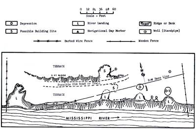 Map of Grey Cloud Townsite by Doug Birk, 1971. Proposed gravel mining and residential development prompted an archaeological survey and cursory investigation of Grey Cloud Island in 1971 by the Minnesota Historical Society. Study focused on the Lower Island. Surface examination was conducted at all mound groups and known or suspected places of settlement. Limited excavation was done at two precontact sites, 21WAl and 21WA9, which had been investigated earlier as part of the Spring Lake area. The main historic focus of archaeological work was the townsite of Grey Cloud, platted in 1856.
|
|
|
Although the location of the town was convenient to river commerce and had been occupied by a few European and mixed-blood farmers since the late 1830s, both the historic and the archaeological records indicate that Grey Cloud failed to develop, becoming farm land again by the end of the 19th century. The artifacts recovered from test pits made there were mainly from the1850s and l860s.
|

|